The proposed Hope Moor Wind Farm raises many questions, but there is one very practical engineering issue that deserves far more attention:
How are the enormous turbine components actually going to get through Newsham and onto the moor?
This is not simply a question of whether a construction lorry can drive along Barningham Road.
It is about whether specialist abnormal-load vehicles carrying turbine blades, tower sections and other extremely large and heavy components can negotiate the actual roads, junctions, walls, properties, gradients and bends around Newsham — and what would have to be altered to make that possible.
My engineering appraisal of Hope Moor deliberately treats access as an unresolved engineering question rather than assuming the answer.
The photographs below show exactly why residents are entitled to see the detailed engineering evidence.
What transporting a turbine blade really involves
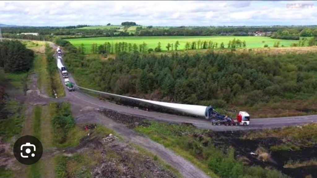
Illustrative example of a turbine-blade abnormal load negotiating a junction. This photograph is not Hope Moor and does not show the exact turbine or transporter proposed for the project.
This first photograph makes the scale of the problem immediately understandable.
Look at the distance between the tractor unit and the end of the blade.
Look at how much space is required around the junction.
The tractor itself is only one part of the equation.
When an extremely long turbine blade is carried around a bend, the blade does not simply follow the wheels of the trailer. The load can sweep far beyond the normal path of the vehicle.
That is why the real question for Newsham is not:
Can a lorry drive along the road?
It is:
Where does the blade go while the vehicle turns?
The Hope Moor engineering appraisal identifies horizontal geometry as a fundamental issue. Long blades and multi-axle trailers require proper swept-path clearance at bends and junctions, including assessment of oversail and control of adjoining land.
Until that work is published, saying that a route is “feasible” is not the same thing as demonstrating how it will actually work.
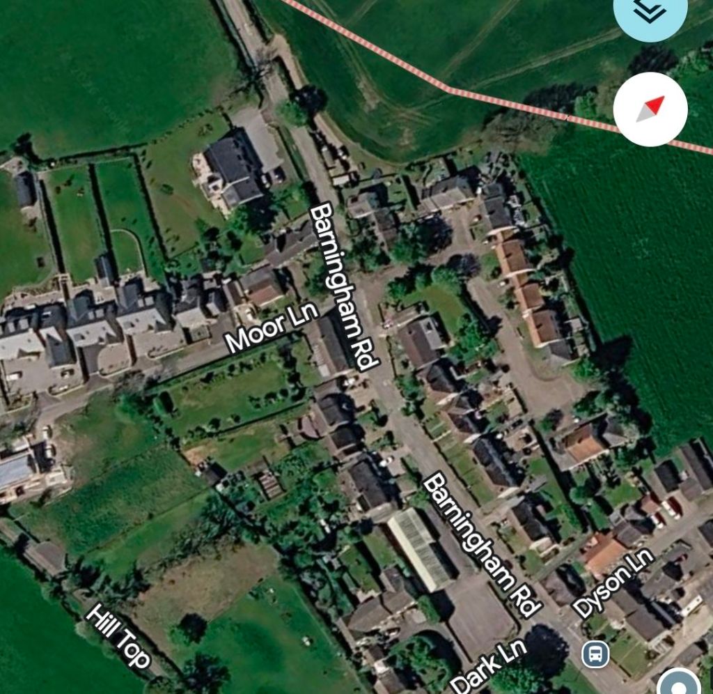
Newsham from above
Satellite view of the Barningham Road and Moor Lane area in Newsham. Homes, gardens, walls, trees and other property boundaries sit close to the road corridor.
This aerial image shows the physical reality of the village.
Barningham Road runs through a built-up settlement.
Moor Lane branches from it among homes, gardens, walls, mature vegetation and established property boundaries.
This is not a purpose-built industrial haul road.
It is a village road network.
And that distinction matters.
The applicant should eventually have to demonstrate not only where the tractor goes, but where the entire abnormal load goes.
That means showing where the trailer wheels travel, where the blade sweeps, where the load oversails adjoining land and whether temporary widening or access over private property is required.
The engineering appraisal sets out what a proper haul-route assessment should contain: the selected turbine transporter, topographical information, swept-path modelling, legal highway and land-control limits, pavement and structural capacity, drainage, temporary works, abnormal-load arrangements and reinstatement.
These are not details that should emerge after consent.
They are fundamental to whether the route works at all.
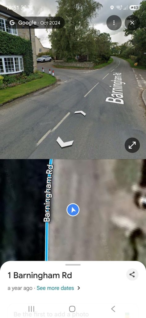
The approach along Barningham Road
Barningham Road in Newsham. The road turns through a residential environment with stone boundaries, mature vegetation and property close to the carriageway.
Now look at the route at ground level.
The photograph shows why a line on a map tells only part of the story.
There is a bend.
There are buildings.
There are stone walls and property boundaries.
There are mature trees and vegetation.
And there is limited open space surrounding the carriageway.
None of that, by itself, proves that an abnormal load cannot pass.
But it demonstrates exactly why proper swept-path drawings are essential.
For every major bend and junction, residents should be shown the path of the tractor, the path of every trailer axle and the complete swept envelope of the turbine component.
If the blade needs to pass above a verge, wall, garden, hedge or neighbouring property, that should be shown.
If vegetation needs to be removed, show it.
If signs or utility equipment need moving, show them.
If additional land is required, identify it.
If permanent or temporary road widening is required, show the extent of it.
Residents should not have to try to work all of this out themselves from Google Maps.
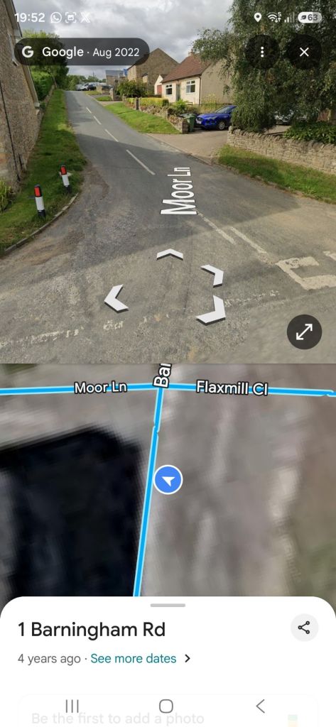
Moor Lane: where the problem becomes even clearer
Moor Lane at Newsham. The road becomes more constrained between property boundaries and rises away from the Barningham Road area.
This photograph may be the most important of the four.
Moor Lane becomes noticeably more constrained.
The available carriageway narrows.
Buildings and stone boundaries sit close to the road.
There is limited verge space.
And the road rises as it moves away from the junction.
That creates two different engineering problems.
The first is horizontal geometry.
Can the full abnormal-load combination negotiate the junction and the narrowing road without unacceptable oversail, overrun or physical alteration?
The second is vertical geometry.
Long multi-axle trailers can be affected by crests, dips, gradients and changes in crossfall. A vehicle may theoretically fit around a corner horizontally but still face problems with grounding, articulation or vertical clearance.
The Hope Moor engineering appraisal specifically identifies both horizontal and vertical geometry as requiring proper vehicle and topographical assessment.
And that is before we consider what lies underneath the road.
It is not only the blades
Turbine blades attract the most attention because of their extraordinary length.
But other components create another set of problems.
Tower sections, nacelles, transformers, cranes and heavy construction equipment can impose very substantial axle loads.
That means Moor Lane and the surrounding roads must be considered not just in terms of width, but also in terms of structural capacity.
Can the road edges withstand repeated abnormal loads?
What condition are the culverts in?
What lies beneath the carriageway?
Will verges require strengthening?
Will drainage have to be reconstructed?
Will stone walls have to be dismantled and rebuilt?
Will passing places or widened corners be necessary?
The engineering appraisal identifies pavement strength, structures and culverts, verges and walls, drainage, ecology and conflicts with other road users as separate matters requiring evidence.
That matters because every road alteration forms part of the real physical and environmental footprint of Hope Moor.
“Feasible” is not the same as “the existing road is suitable”
This is the distinction that needs to be understood.
A developer may eventually be able to engineer a solution.
But that does not mean that the existing route is suitable in its present condition.
A route can potentially be made technically feasible by widening roads, obtaining land rights, altering walls, clearing vegetation, strengthening road edges, modifying drainage and creating temporary works.
That is very different from saying these turbine components can simply travel through Newsham as the roads stand today.
My engineering appraisal deliberately avoids claiming that Moor Lane has already been proved physically impossible.
Instead, it reaches the more defensible conclusion that Moor Lane remains an unresolved, high-risk haul option for which full engineering evidence is still required.
That is the proper position.
The burden should now be on the developer to demonstrate exactly how the route will work.
Publish the swept-path drawings
Before anybody accepts that Newsham can accommodate the abnormal loads required for Hope Moor, residents should be shown the engineering.
Show us the dimensions of the turbine components being assessed.
Show us the transporter.
Show us the complete swept path at the Barningham Road and Moor Lane junction.
Show us the vertical profile.
Show us the blade oversail.
Show us the wheel overrun.
Show us every piece of private land affected.
Show us every wall, hedge and tree that may require alteration.
Show us any utilities that have to be moved.
Show us the pavement investigations.
Show us the culvert assessments.
Show us the road widening.
Show us the temporary works.
Show us the reinstatement proposals.
And show residents how access to homes, farms and local roads will be maintained while these movements take place.
The engineering appraisal calls for both haul options to be audited using the final delivery vehicle, ground investigation and all temporary and permanent widening limits.
That is not unreasonable opposition.
It is basic engineering transparency.
One photograph asks the whole question
Go back to the first photograph.
Look at the amount of space required to transport a modern turbine blade around a bend.
Then look at the photographs of Newsham.
Look at Barningham Road.
Look at the buildings.
Look at the walls.
Look at the vegetation.
Then look at Moor Lane.
Those photographs do not prove that a Hope Moor blade cannot get through.
And we should not pretend that they do.
The engineering paper itself specifically warns against claiming that photographs or Google Maps alone prove a haul route impossible.
But the reverse is equally important.
They show why residents should not simply be expected to accept that the route can accommodate these loads without seeing the engineering evidence.
The responsibility for proving that belongs with the developer.
Until the detailed abnormal-load assessment is published, Newsham residents are entitled to keep asking one very simple question:
Where does the blade go?
Shane Oxer. Campaigner for fairer and affordable energy
 SAY NO TO THE DESTRUCTION OF OUR LAND
Leave a comment