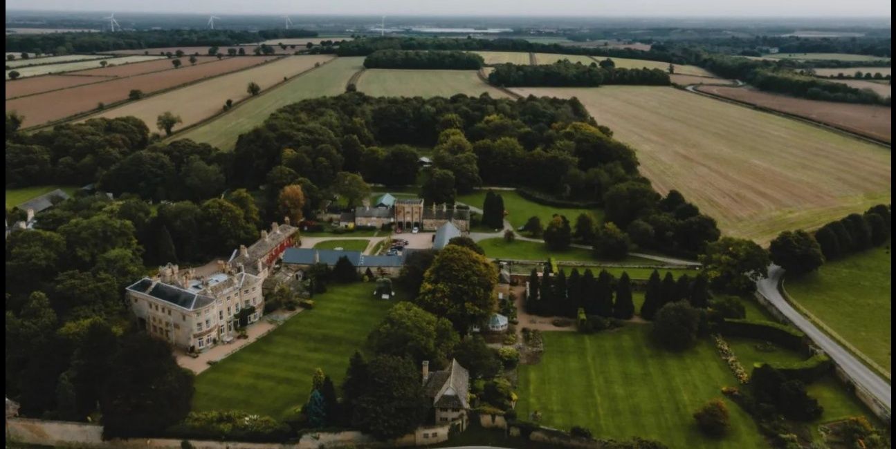
Hooton Pagnell Hall and the historic landscape surrounding it.
There are some places whose value is difficult to express on a planning form. Hooton Pagnell is one of them. Seen from above, the village does not appear as a collection of buildings sitting independently in the countryside, but as something woven into it: stone walls, mature trees, open fields, old lanes and woodland gathered around a settlement that has grown through centuries rather than decades.
At the centre of that landscape stands Hooton Pagnell Hall, a Grade II* listed building whose history reaches back to the medieval period. Around it lies the village conservation area, designated on 22 June 1970, containing the Grade I Church of All Saints and a remarkable concentration of listed buildings and historic structures.
Doncaster Council itself acknowledges that, despite the designation being more than half a century old, a full conservation-area appraisal has still not been carried out.
That omission might once have seemed largely administrative. It is rather harder to dismiss today, because immediately to the south of Hooton Pagnell a major solar and battery development is proposed.
Planning application 25/02389/FULM concerns a ground-mounted solar photovoltaic array, battery energy storage and associated infrastructure on land at Bilham Lane.
British Solar Renewables describes its proposal as extending across approximately 94 hectares to the south of Hooton Pagnell.
Ninety-four hectares is difficult to picture when written on a page.
The photograph above makes the question more tangible. It shows a landscape whose character comes not from one isolated monument, but from the relationship between the Hall, village, fields, trees and the long sweep of countryside beyond them.
That relationship is not merely picturesque. It is historically documented.
Yorkshire Gardens Trust has researched the designed landscape surrounding Hooton Pagnell Hall in considerable detail.
Its work identifies approximately 84 acres, or 34 hectares, of historic designed landscape, and records that the Hall overlooks an arable landscape with long views to the south and west. It also notes that only the northernmost part of Mapple Yard falls within the existing Conservation Area, while the historic landscape itself extends further, with its southern boundary reaching towards Butt Lane.
That becomes especially significant when the history of the Hall itself is considered. In 1787 its south front was substantially remodelled, with full-height bow windows introduced at either end and an outlook deliberately created towards the south.
The surrounding land was also reshaped during the late eighteenth century, with Mapple Yard enlarged and landscaped with tree clumps and shelter belts.
Yorkshire Gardens Trust records that much of this historic arrangement remains legible today.
In other words, the countryside to the south was not simply empty land beyond the house. It formed part of the way the Hall was designed to be seen from, lived in and understood.
That is why the present proposal deserves particularly careful scrutiny.
The developer states that the listed and non-listed architecture of Hooton Pagnell “will not have visibility of the site.” That may ultimately prove capable of being demonstrated through topography, vegetation and the final disposition of panels, but it is a conclusion that should be tested rather than simply accepted.
The historic evidence tells us that the Hall was deliberately oriented towards the southern landscape and that long views to the south and west form part of its documented setting.
The proposed development lies precisely to the south of the village.
The photograph does not, by itself, prove that solar panels would be visible from every window of the Hall. It should not be used in that way.
What it does show is why the question matters.
There is an openness to this landscape, an evident visual relationship between the Hall and the countryside around it, that cannot be reduced to a line drawn around a planning application.
Before the application is determined, it seems reasonable to ask whether viewpoints from the Hall itself were assessed;
whether its south-facing rooms, gardens and historic designed landscape were included within the Zone of Theoretical Visibility;
whether representative views were taken from Mapple Yard; and how the applicant reconciles its conclusion of no visibility with the independent heritage research documenting long southern and western views.
There is a wider question too, and perhaps a more enduring one.
Conservation Areas are lines on maps, but history rarely observes administrative boundaries. Hooton Pagnell’s present Conservation Area dates from 1970, yet Yorkshire Gardens Trust’s later research identifies important historic landscape lying beyond it.
Only the northernmost portion of Mapple Yard is included within the designation, despite the wider landscape having been deliberately shaped and connected with the Hall for more than two centuries.
That does not mean every field around Hooton Pagnell should automatically be protected from change. Nor does it mean that the existence of a historic landscape settles the planning application one way or another. It does mean, however, that the significance of the place ought to be properly understood before decisions are made which could alter its character for decades.
There is something easy to lose when planning decisions become dominated by capacity figures, megawatts, grid connections and mitigation plans.
The countryside becomes hectares. A view becomes a receptor. An ancient village becomes a constraint on a site plan.
But landscapes are experienced differently by the people who know them.
They are recognised in the rise of the ground, the line of an old wall, the shadow of woodland across a field and the way a house has looked across the same horizon for generations.
The beauty of Hooton Pagnell does not arise from any one of those things.
It comes from all of them together.
That is what the photograph captures.
The Hall is important, but so too is the land around it.
The village is important, but so too are the fields into which it opens.
The historic buildings matter, but so does the setting which has allowed them to remain rooted in something recognisably rural.
Solar panels and battery compounds may be temporary in planning terms. Forty years may be described as a limited operational period.
Yet forty years is a considerable portion of a human life, and the effect of transforming a landscape cannot sensibly be understood only by asking whether the equipment can eventually be removed.
There are places where development may sit comfortably in the landscape, and places where the landscape itself demands a more searching question.
Hooton Pagnell surely deserves that question.
Look again at the photograph: the Hall among its trees, the old village beyond, the patchwork of fields running southward and westward, the countryside opening towards the horizon. Then consider the scale of the proposal. 94 hectares of solar and battery development immediately to the south of this historic settlement.
Before a decision is made, the Council should be satisfied not merely that the proposal complies with lines on a map, but that the historic relationship between Hooton Pagnell and the landscape around it has genuinely been understood.
Because once that landscape has been seen in its entirety, the question becomes difficult to avoid:
Would you really choose a landscape this beautiful for development on this scale?
SourcesCity of Doncaster Council — Hooton Pagnell Conservation AreaHistoric England — Hooton Pagnell Hall, National Heritage List for EnglandYorkshire Gardens Trust — Hooton Pagnell Hall historic designed landscape researchCity of Doncaster Council — Planning application 25/02389/FULMBritish Solar Renewables — Hooton Pagnell Renewable Park
Shane Oxer. Campaigner for fairer and affordable energy
 SAY NO TO THE DESTRUCTION OF OUR LAND
Leave a comment